 |  |  |  |  |  |  |  |  |  |  | |
www.kitzastro.net

Französisch Polynesien 2018
Tahiti
|
|
Tahiti is the largest island of french overseas territory French Polynesia and also the economic centre of the region. Tahiti is a double island - Tahiti Nui (big Tahiti) in the north and Tahiti Iti (little Tahiti) in the south. Both islands are connected by the isthmus of Taravao. Tahiti is from volcanic origin, like all islands of the region - in the center of Tahiti Nui the 2241 meter high volcano mount Orohena overtops the islands. |
 |
| Willkommen in Tahiti - eine kleine tahitianische Schönheit von morgen begrüßt uns am Flughafen von Papeete. Welcome to Tahiti - a tomorrows tahitian beauty welcomes us at Papeete airport. Sony RX10-III |
 |
| Tahiti ist sehr gebirgig - hohe Berge bilden das Zentrum der Insel... Ther are many mountains in Tahiti - they are located in the center of the island... Sony RX10-III |
 |
| ...die meist in Wolken gehüllten Berggipfel (bis 2.241m hoch) sind nur manchmal frei zu sehen. ...the mountain tops (up to 2.241 meters high) are often covered in clouds but visible from time to time. Sony RX10-III |
 |
| Tahiti ist eine Doppelinsel - der kleinere Südteil (Tahiti Iti = Klein-Tahiti) ist genauso gebirgig (höchste Erhebung 1.332m)... Tahiti is a double island - the smaller south (Tahiti iti - small Tahiti) is as mountainos as the main island (highest point 1.332 meters)... Sony RX10-III |
 |
| Blick
von Tahiti Iti Richtung Nordwesten zur wolkenverhüllten Hauptinsel
Tahit Nui (= Groß-Tahiti). Dazwischen ist der Isthmus von Taravao zu
sehen, der die beiden Teile verbindet... Northwest view from Tahiti Iti to Tahiti Nui (= big Tahiti). In between lies the isthmus from Taravao which connects both parts... Sony RX10-III |
 |
| Das Riff vor Tahiti Nui - die Wellen brechen dort und die Ufergewässer bleiben ruhig. The reef of Tahiti Nui - the waves burst there and the coast waters stay calm. Sony RX10-III |
 |
| Tahiti Iti ist nicht vollständig erschlossen - die Straße endet bei Teahupoo... Tahiti Iti is not fully developed - the street ends ad Teahupoo. Sony RX10-III |
 |
| Die Wellen brechen vor Teahupoo... Bursting waves outside Teahupoo... Sony RX10-III |
 |
| Motu Nono vor Tahiti Iti. Motu Nono outside Tahiti Iti. Sony RX10-III |
 |
| Point Venus - von hier aus beobachtet James Cook den Venustransit 1769... Point Venus - from here James Cook observed the Venus transit in 1769... Sony RX10-III |
 |
| Der Leuchtturm von Point Venus ... The Lighthouse of Point Venus... Sony RX10-III |
 |
| ...25 Meter hoch und im Jahr 1868 erbaut. ...25 meters tall and built in 1868. Sony RX10-III |
 |
| Rosa Kirche.....die protestantische Kirche Eglise De Mahina unweit von Point Venus. Pink church...Temple protestant de Mahina near Point Venus. Sony RX10-III 6D |
 |
|
Kirche von Taravao - am Isthmus der Tahiti Nui und Tahiti Iti verbindet...
L´église de Taravao - at the isthmus connecting Tahiti Nui and Tahiti Iti... Sony RX10-III |

|
|
Municipal Market - Markt von Papeete...
Municipal Market - market of Papeete... Sony RX10-III |
 |
| ...Markt von Papeete - da darf natürlich Fisch nicht fehlen... ...Papeete market - of course fish included... Sony RX10-III |
 |
| ...eigentlich wollte ich die ja unter Wasser sehen :-) ...actually I wanted to see them under water :-) Sony RX10-III |
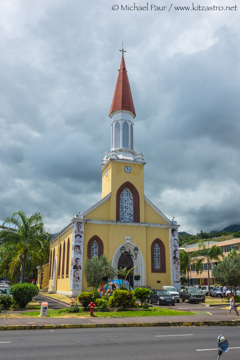 |
| Kirche von Papeete - Cathedrale de Notre Dame. Church of Papeete - Cathedrale de Notre Dame. Sony RX10-III |
 |
|
Blick von Tahiti zur Nachbarinsel Moreea...
View from Tahiti to it´s neighbour island Moreea... Sony RX10-III |
 |
|
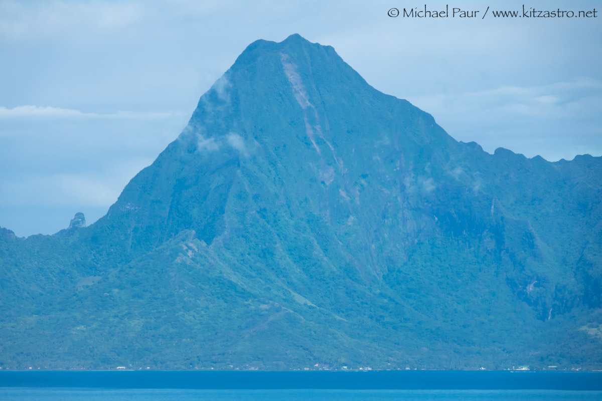
Mount Tohiea - höchste Erhebung von Moorea (1.207m).
Mount Tohiea - highest point of Moorea (1.207 meters). Sony RX10-III |
 |
|
Sonnenuntergang - rechts das wolkenverhangene Moorea.
Sunset - with cloud covered Moorea at the right. Canon EOS 6D |
...weiter nach Rangiroa:
 |